Letter from Cebu (9) ”The Philippine Sea Plate has created the Landscape of Cebu”
2022/9/28
Letter from Cebu (No.9)
“The Philippine Sea Plate has created the Landscape of Cebu”
“The Philippine Sea Plate has created the Landscape of Cebu”
The media in Japan recently reported theories that try to explain the formation of the Japanese Archipelago from the so-called plate tectonics, paying attention to the movements of the Pacific Plate or the Philippine Sea Plate.
One of the widely reported theories is that about 3 million years ago, the Philippine Sea Plate, which had been moving from south to north, changed its direction to Northwest, due to the pressure of the Pacific Plate from the east. This change of direction resulted in narrowing the distance between the Japan Trench and the Tohoku region, lifting the mountains of the Tohoku region, and creating a geological active fault line passing through Kyushu, the western part of Japan and Kanto, the middle of Japan, called ‘chuo kouzou sen’.
The Izu peninsula, used to be submarine volcano groups lying on the Philippine Sea Plate 20 million years ago, located at around the same latitude as that of the current Iwo to. The volcano groups drifted to Japan as the Philippine Sea Plate moved to the north, and collided with Honshu, Japan’s main island about 1 million years ago, and formed a peninsula about 600 thousand years ago.
Many people in Japan are familiar with the influence of the Philippine Sea Plate movement in forming the Japan Archipelago, but not many are aware of the impact of the Philippine Sea Plate on the formation of the Philippine Archipelago.
The Philippine Sea Plate is a diamond shaped, relatively small plate, surrounded by the Pacific Plate to the east, the Eurasian Plate to the west, and the Australian Plate to the south. The northwest side of the plate is faced with the Nankai Trough, off the coast of southwestern Japan, and the southwest side of the plate is faced with the Philippine Trench, off the coast of East Philippines.
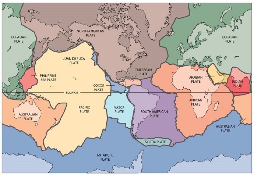
USGS. (2012, August 7). Historical Perspective [Online Image]. https://pubs.usgs.gov/publications/text/historical.html
Credit: U.S. Geological Survey, Department of Interior/USGS
When we look at the plate movements around the Philippines, we notice that the Pacific Plate is subducted beneath the Philippine Sea Plate along the Izu-Ogasawara Trench, the eastern boundary of the Philippine Sea Plate. The Philippine Sea Plate, due to the pressure from the east, is subducted under the Philippines along the Philippine Trench and the East Luzon Trench.
On the other hand, the Eurasian Plate is subducted beneath the Philippines along the Manila Trench, Negros Trench and Cotabato Trench. These two simultaneous subductions are unique to the Philippines.
The area where the two plates are subducted comprises most of the Philippine Archipelago, called the Philippine Mobile Belt. There are active volcanic activities along this Belt. There are five volcanic arcs in the Philippines; the Luzon volcanic arc, the East Philippine volcanic arc, the Negros-Panay volcanic arc, and the Sulu-Zamboanga volcanic arc. The Mount Pinatubo, that caused the largest terrestrial eruption in the 20th century, belongs to the Luzon volcanic arc. Eighty four volcanoes are identified and 22 volcanoes are active.
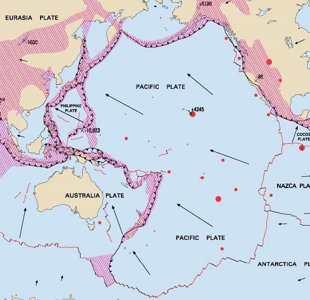
Simkin, T., Tilling, R., Vogt, P., Kirby, S., Kimberly, P., Stewart, D. (2006). Pacific Plate boundaries and relative motion. This Dynamic Planet: World Map of Volcanoes, Earthquakes, Impact Craters, and Plate Tectonics Third Edition. Retrieved from https://www.usgs.gov/media/images/pacific-plate-boundaries-and-relative-motion
Cartography and graphic design by Will R. Stettner with contributions by Antonio Villaseñor and edited by Katharine S. Schindler.
Credit: Smithsonian Institution, U.S. Geological Survey, U.S. Naval Research Laboratory, Jaume Almera, Institute of Earth Sciences, Spanish National Research Council
(Philippine Volcanoes)
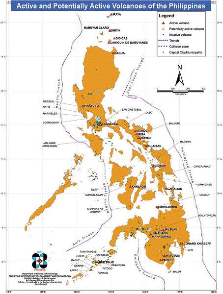
Reference:Volcanoes of the Philippines. (n.d.). Retrieved from https://www.phivolcs.dost.gov.ph/index.php/volcano-hazard/volcanoes-of-the-philippines
The two simultaneous subductions of the plates has created the Philippine Fault. This is a large scale, 1,200 km in length, active fault from Luzon island, along the east side of mid-Philippines, to the Mindanao island. The Philippines is an earthquake prone country. When we look at the record of earthquakes in the country in the last 500 years, we realize that most of the earthquakes occurred along the Philippine Fault, or along the Philippine Trench and the Manila Trench.
(The Philippine Fault)
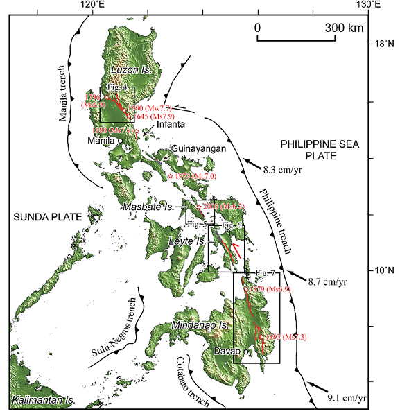
Fig. 1. Tectonic framework of the Philippine archipelago. Red lines denote traces of the Philippine fault based on interpretation of aerial photographs whereas purple lines denote those based on interpretation of shaded relief and topographic maps. Red arrow indicates the leftlateral motion on the Philippine fault. Red open stars show large historical earthquakes along the Philippine fault from Bautista and Oike (2000). Black lines with triangles denote subduction boundaries with arrows showing relative motion between the Philippine Sea plate and Sunda (Eurasia) plate from Seno et al. (1993).
Reference: Tsutsumi, H., & Perez, J.S. (2013). Large-scale active fault map of the Philippine fault based on aerial photograph interpretation. Retrieved from https://www.semanticscholar.org
Reference: Tsutsumi, H., & Perez, J.S. (2013). Large-scale active fault map of the Philippine fault based on aerial photograph interpretation. Retrieved from https://www.semanticscholar.org
Most of the Philippines are exposed to active geological activities like volcanoes and earthquakes. However, the area around Cebu island and surrounding islands are relatively free from these activities. There are no volcanoes in Cebu, while the Negros island has one (Kanlaon). The Philippine Fault cuts across the Leyte island, not Cebu.
Cebu and surrounding islands used to be the seabed of the relatively shallow sea up until hundreds of millions of years ago, and covered with coral reefs. They started to be lifted in the late Neogene (about 23 million to 2.5 million years ago), and the lifting lasted until recently. Therefore, Cebu island and surrounding islands are covered with limestones (Coral reef turned into limestones.) The islands were surrounded by shoals less than 3 meters in depth, and the width of the shoals are 100 meters to 200 meters. Sand is very white because it originates from coral.
It is amazing that Cebu, while being located in the Philippine Mobile Belt, was gradually lifted from the seabed, and attract a number of divers with its beautiful coastal line and coral reefs.
(Beautiful beaches of an island near Cebu)
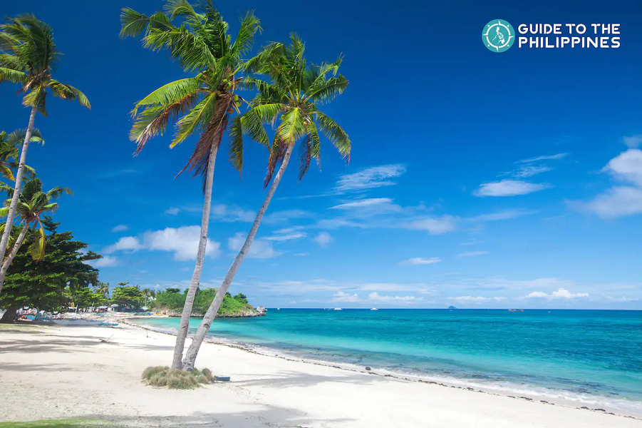
Langub Beach, Malapascua Island, Cebu
Reference:Berida, Joshua. Photograph of Langub Beach, Malapascua Island “Best 15 Beaches in Cebu Philippines”. Guide to the Philippines. https://guidetothephilippines.ph/articles/islands-and-beaches/cebu-top-beaches
Reference:Berida, Joshua. Photograph of Langub Beach, Malapascua Island “Best 15 Beaches in Cebu Philippines”. Guide to the Philippines. https://guidetothephilippines.ph/articles/islands-and-beaches/cebu-top-beaches
Hideki YAMAJI
Consul General of Japan in Cebu
Consul General of Japan in Cebu
(Reference)
“Evolution and Classification of Volcanic Edifices on the Philippine Islands”, Ichio MORIYA, Journal of Geography, 123(1)89-122 2014
“Evolution of Geographical Structure of the Philippine Islands”, Yasumoto SUZUKI, Geography News 413, January 1989
“Evolution and Classification of Volcanic Edifices on the Philippine Islands”, Ichio MORIYA, Journal of Geography, 123(1)89-122 2014
“Evolution of Geographical Structure of the Philippine Islands”, Yasumoto SUZUKI, Geography News 413, January 1989
(end)